by Fred
Snapper, when the Superbank lights up
Snapper Rocks is the start of the Superbank, a sand-pumped point that needs the right swell, the right period, and the right wind. Here's the recipe, with the next five days on the Gold Coast as the live read.
Snapper Rocks gets called world-class and a circus in the same breath. Both are right. When it lines up, the right-hander peels off the rock and joins the Superbank, kilometre-long walls running all the way to Kirra. When it doesn’t, it’s a wrestling match with 200 of your closest mates. Here’s what it needs, with the next five days on the Gold Coast as the live read.
The CT’s in town. The Bonsoy Gold Coast Pro 2026 runs from May 1 at Snapper, closing the GWM Aussie Treble after Bells and Margs. Useful test case.
Live numbers on the Gold Coast forecast page.
What Snapper wants
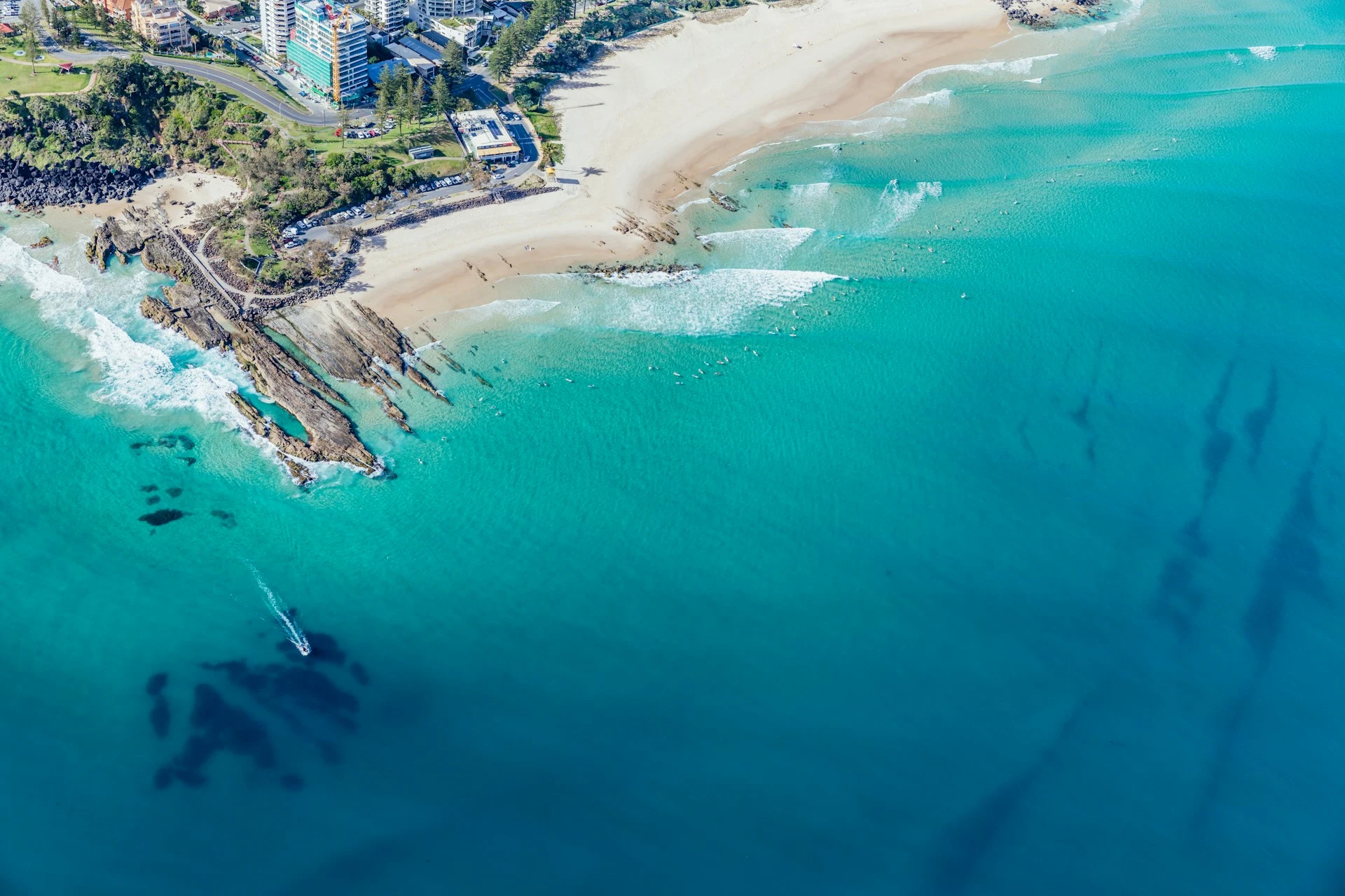 Photo by City of Gold Coast
Snapper sits at the southern tip of the Gold Coast, where the NSW border bends into Queensland. On the right swell, the wave links from the rock through Rainbow Bay, Greenmount, Coolangatta and Kirra. That’s the Superbank, sand pumped north out of the Tweed River by the bypass system since 2001. Four separate points before the pump, one wave when the bank holds.
It’s a Mick Fanning, Joel Parkinson and Stephanie Gilmore wave. The takeoff is a fast drop off the rock into a sand-bottomed point that walls and barrels through the Quiksilver tower, sometimes never closing until Greenmount.
Productive swell window is ENE through SE, roughly 70 to 145 degrees. East is the most common producer. South of 145, Cook Island and the Australian coast block the energy, though long-period south swells can wrap in. North is blocked by the headland.
Period is the other half. Twelve seconds and up is where the wall connects from the rock through Little Marley into Rainbow. Under that, sections fall over before you can join them.
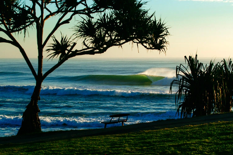 Photo by Andrew Shield/WSL
Size sweet spot is 1 to 2.5 m. Smaller, the bank doesn’t activate up the line. Bigger, the takeoff narrows to a shallow slot with the rocks right there if you blow it.
Wind wants light, or south through southwest. That’s the offshore window. The Snapper quirk: the wave wraps so hard around the headland that it ends up facing into a southerly, so when a buster shuts the rest of the Goldy down, Snapper stays clean. Northerly is straight onshore. East and southeast winds (not swell) are sideshore and chop up the inside.
Tide: mid is safest. Dead low exposes the boil off the rock; dead high softens the wall.
Then the crowd. Snapper on a swell is the heaviest lineup in Australia. Pros, ex-pros, thirty-year locals, plus every visitor on the Goldy. Sit wide, take scraps. Paddle out at Rainbow Bay, not off Snapper, unless you want to wear a fin.
The next five days
The good news: the swell is east and east-southeast all week, slap in the middle of Snapper’s productive window. Period builds the whole time, from wind swell on Friday to long-period swell by Tuesday. The variable is wind. There’s no southerly buster on the cards, and most of the week the breeze sits in the east, which is the wrong side of the headland for Snapper.
Friday May 1. Wave height 2.0 to 2.2 m, period 8 s, swell coming in from the east-southeast. That period is wind swell territory, so expect the bumpier, weaker version of Snapper even with the angle on. Wind is the problem: 17 to 18 knots from the east-southeast through southeast, sideshore at the takeoff. Power around 17 to 19 kW/m, a solid average day on the meter, but it’ll look messy.
Saturday May 2. Size peak. Wave height climbs to 2.7 m by mid-morning, period stretches out to 9.5 s, swell straight east-southeast. Power kicks to 31 kW/m, the most energetic block of the window. Catch is the wind: 18 to 21 knots out of the east. Onshore at the point, in the bigger surf. Heavier-water day, not a clean one.
Sunday May 3. The change. Same swell on the way down, 2.0 to 2.2 m at 9.6 s, still from the east. Wind drops back: 13 knots in the morning, then 10 to 11 knots through the arvo, still leaning east-southeast. Not glass, not offshore, but a lot more workable. Power around 18 to 24 kW/m. The crowd will read this as the day to go.
Monday May 4. Wave height holds 2.1 to 2.4 m, period 9.6 to 10.8 s, swell still east. Wind sits 9 to 14 knots from the east through east-northeast all day, sideshore. Not the clean morning offshore some forecasts will sell you. Power climbs through 22 to 32 kW/m as the period stretches out. The waves themselves are real; the wind keeps it textured.
Tuesday May 5. Forecast cuts off late afternoon local. What we have shows wave height 2.0 to 2.5 m at 11 seconds, swell still east, wind dropping to a light 6 to 10 knots from the east-southeast. Long-period swell with the wind backing right off. Lightest breeze of the window over the cleanest period. If it holds, it’s the best banks of the week.
Takeaway: the angle is there all week, but the breeze stays parked in the east through Monday. No southerly to flip the script in Snapper’s favour. Tuesday is when the wind finally backs off, and that’s the day to be on it.
What it looks like when it’s on
The classic Snapper day is well-documented. Long lines wrapping the rock, the Quiksilver tower section throwing, then walls all the way down the bank. Mick won his world titles on it. Parko grew up living above it. Steph still surfs it most mornings she’s home.
When the east-southeast lines, a southwesterly offshore and the sand all line up at once, it’s the longest rideable point on the east coast.
That’s Snapper on. The swell angle this week is in the right window. The wind isn’t quite, until Tuesday.